Nooksack Falls Hydro Project
|
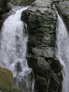
The Nooksack Falls project, a hydropower facility originally constructed in 1906, has not been in operation since 1997, but plans to resurrect the project could have an impact on recreational opportunities. For paddlers, the primary concern would likely be access as the project would dewater the last few hundred yards of whitewater to the take- out at the pool above Nooksack Falls, which would necessitate legal access at the diversion dam. In summer 2002 the Federal Energy Regulatory Commission (FERC) released a navigation report. The following information is adapted from that report to provide paddlers with background context regarding the history of navigation and commerce on this river. It is supplemented with information provided by local paddlers (the original report can be obtained from FERC).
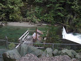
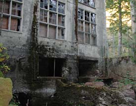
Project Background The project is located on the North Fork of the Nooksack River on private lands within the Mount Baker-Snoqualmie National Forest, between river mile 64.3 and 62.7. Initial construction was in 1906, and in 1912 the USDA granted Puget Sound Power and Light Company an easement for a 7.3-mile-long, 50-foot-wide transmission line through National Forest Land. In 1962, the US Forest Service determined that the pre-1920 permit, which had no stated expiration date, had a 50-year limit by regulation. The Forest Service sent a letter to the Federal Power Commission, requesting a jurisdictional determination of the project. The Forest Service granted a new easement to Puget Sound, which was extended until June 30, 2001. In 1964, the FPC sent a letter to Puget, notifying them that the transmission line through National Forest land was a primary line, and therefore Puget must apply for a license for the Nooksack Falls Project. In 1982, Puget filed an application for a license for the Nooksack Falls Project, P-3721. On January 23, 1997, while the license application was pending, the generator at the Nooksack Falls Project was destroyed by fire, and in 1999 Puget withdrew its application after deciding not to make repairs. The project facilities were transferred to a new owner, Welcome Springs, and on January 4, 2001, FERC granted a new preliminary permit for the Nooksack Project (11857-00). As proposed in the permit application, the "new" project would consist of (1) an existing dam that is 60-feet-long, 15-feet-high plank with concrete toe; (2) an existing impoundment with a 0.5 acre surface area; (3) an existing intake structure; (4) and existing 467-foot-long concrete flume; (5) and existing 566-foot-long wood stave pipe; (6) an existing 1,025-foot-long, 7-foot by 8-foot unlined tunnel; (7) an existing surge tank; (8) an existing 564-foot-long, 6-foot-diameter steel penstock; (9) and existing powerhouse containing four generating units having a total installed capacity of 1.5 MW; and (10) apartment facilities. As of summer 2002, many of the project works, listed in the Preliminary Permit application, are no longer at the project site. The Nooksack Falls Project appears abandoned and has fallen into disrepair. The powerhouse has broken windows and structural damage, and there is no evidence that the interior of the powerhouse has been maintained. The area surrounding the powerhouse and project works has grown up in brush and timber. Sections of the penstock have also been removed. The 566-foot-long wood stave pipe has also fallen into disrepair, and the 1,025-foot-long tunnel is filled with debris. Finally, there is no evidence of a surge tank.
The North Fork of the Nooksack River has been used, or has shown that it is suitable for use for the transportation of persons and property in interstate commerce. Historical evidence indicates that the river was used by Native Americans for transportation and the movement of goods. For members of the Nooksack Tribe, the river corridor was an important means of travel as overland passage through the dense stands of virgin forest was extremely challenging. In the 1860's the first European exploration of the river occurred when Edmund Coleman and his colleagues traveled from Canada, up the Nooksack River to Mount Baker and returned. Apparently they, along with guides from the Nooksack Tribe, canoed up the North Fork on the first expedition, and probably on the second, and returned by way of the North Fork (the details of the trip are described in the November 1869 issue of Harper's New Monthly Magazine, 39(234):797-817). Throughout this river's recorded history, there is evidence of canoeing from the mouth of the river to Mount Baker by Native Americans, and by later European- American settlers up to at least as Everson and probably to Maple Falls, Glacier, and Excelsior. Steamboats also carried passengers and freight up the river, as far as Everson. Early on, logging quickly became the region's most important industry. Loggers were very active on the river from the 1880's, with a major boom established at the mouth of the river, for transportation of logs to Canada. Shingles and logs were also floated down the river, past the current project site, to mills in Maple Falls, Everson, and other sites along the river. One of the primary sites for Erb Timber and Shingle Manufacturers was near Excelsior Mine located near Wells Creek which enters the river within the project site at the base of Nooksack Falls. Bolts of shingles were held until conditions permitted floating them down Wells Creek and out onto the Nooksack River past the present site of the Nooksack Falls Project. Through the second half of the 20th century, sections of the river were used, and continue to be used by commercial rafting companies and recreational boaters from above Nooksack Falls to the mouth of the river in Bellingham, WA. The most popular whitewater reach is the class III section from Douglas Fir Campground to a take-out along Highway 520 downstream of the canyon, and just upstream of the town of Maple Falls (description). This is a popular commercial rafting trip in late summer because the glaciers on Mt. Baker provide dependable flows throughout the summer when other area rivers start to drop. Trips typically occur until endangered Chinook salmon begin spawning in late August, which prompts an annual boating closure of this section of the river by the Forest Service. Additional class IV and V whitewater opportunities are available in the Misto Gorge run above Nooksack Falls which passes through the upper half of the project site and ends at a take-out in the pool above the falls, and in the Horseshoe Bend section below the falls that ends at Douglas Fir Campground. These sections were not regularly paddled until the 1990's but advances in technique and equipment along with increased popularity of the sport have made this reach more popular over the past decade.
FERC concluded that the North Fork of the Nooksack River has been, and continues to be used for a variety of activities. The entire river system is suitable for the simplest forms of commercial activity and is a navigable water of the United States, as defined by Section 3(8) of the Federal Power Act. Although the project bypass reach is short, the project would have an impact on whitewater recreational opportunities and potentially access to the river for the expert canyon section that ends at the pool above Nooksack Falls. This text was adapted from the Navigation Status Report for the North Fork Nooksack River, prepared by FERC and filed 9 August 2002 under docket number 11857-000. The full report can be retrieved from FERRIS (FERC's online document retrieval system). |


