Cumberland, Big South Fork
3. Station Camp to Blue Heron, KY (19 miles)
| Difficulty | II+(IV) |
| Length | 60.1 mi |
| Avg Gradient | 5 fpm |
| Gauge | South Fk Cumberland River at Leatherwood Ford, Tn |
| Flow Rate as of 35 minutes | 141 cfsbelow recommended |
| Reach Info Last Updated | December 12, 2025 |
River Description
It should be noted that this reach (as listed here) has a fair stretch of mostly flatwater, but which contains a good (class III/IV) drop, Devils Jump. Photos of that drop do exist on the photo tab.
John Foy contributed:
Great canoe camping river. Give yourself two days for Station Camp to Blue Heron, three for Station Camp to Yamacraw Bridge. Basically flatwater/lake beyond Yamacraw. Good fishing for smallmouth and catfish along the entire river. Be careful during rainy periods as this river rises very rapidly. I like it best between 100 and 500 cfs at Stearns.
A fine reference for this is Canoeing and Kayaking Guide to the Streams of Tennessee, B. Sehlinger
River Features
Put In
Piss Your Pants
This rapids name comes from the scare you'll get after paddling the predominantly flat/class I water before. No real danger, it's just a long wave train that should be run right and then left at the bottem to avoid some rocks.
Chicken's Foot
A three chute drop that us prone to having wood in the middle chute. Run the far left line, the right usually is too low to run, unless the water level is over 2500 cfs.
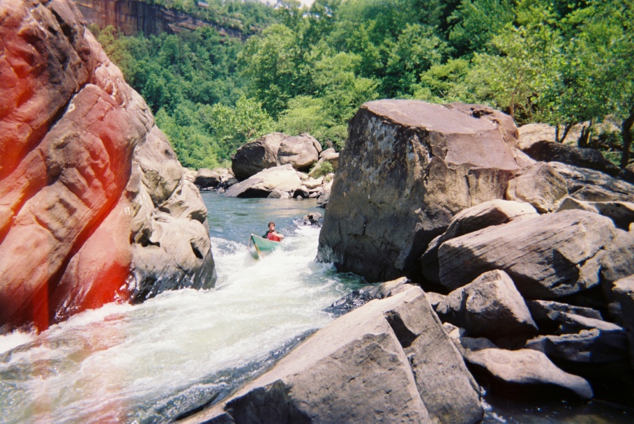
Devil's Jump
Noted by two high overlook platforms on the rim of the gorge on river right. The river narrows down to about a 10 ft chute and drops about 4 feet and then washes into an undercut rock at lower levels. The higher the water the easier to avoid the undercut. The rapid requires an S-move similar to Nantahala Falls. At flows above 1,000cfs a right class III line opens up, but use caution if you are not a class IV boater, because getting out of the main current and into the big eddy above the right line is difficult. This line has a 4 ft drop onto a slightly undercut rock that with enough momentum will be missed completely. There's a pretty good recovery pool at the bottom.
Take Out
Trip Reports
Log in to add a reportCaution with open boats at high flows - Kylie Schmidt
Aug 12, 2023
Day 2 - Station Camp to Ship Rock Area
We left Station Camp around 11:30am, with a flow around 600 cfs for the entire day. The water moves fairly quickly in this section, as there isn't much flat water. We made it to the Big Island within an hour (~3mph), and we paddled close to this pace all day. I thought this section was more scenic than the Leatherwood to Station Camp section, but it's all wonderful. Lots of interesting rock and river features to stop and enjoy in this stretch, so an earlier start would be preferred (a member of our team got food poisoning our first night - a lesson to be prepared). At this level, there were no safe camping sites at Ship Rock itself, but there was a lovely sandy bank on river right not even a mile further down. We arrived at this site around 7pm. The hiking trails run along the river here so I'm sure there's plenty of other spots off the river. I would not run this river without having a map of the hiking trails, not only for an emergency, but also for finding higher ground camping.
Day 3 - Ship Rock Area to Blue Heron
The flow rose to over 6100 cfs by 7am. We nearly lost a boat and a paddle because our 'safe' zone wasn't safe enough. I will always tie off boats and better secure loose items because of this. Thankfully one of our tents was just safe enough, but the water got within 2' of it. We delayed our departure to let things settle a little and thinking our day would be expedited due to the flow. However, two members of our group had open rec boats and they were no match for the big waves this flow brought. Thankfully they still floated when full of water once the paddler bailed, but this meant pulling over to drain boats after nearly every rapid. We left camp close to noon, with a flow around 4700, but we didn't make it to the Devil's Jump Portage until 5-5:30pm because of the constant draining. I would highly advise against an open rec boat because of this, and I would think a canoe at these levels would also be a nightmare (but I've never run a canoe). Rapids were likely II+, with 3-4' waves.
There is an obvious structural overlook on the most striking cliff you have seen on the whole section that signifies Devil's Jump is ahead. The portage is somewhat uncomfortably close to the rapid at this level, as the flow is a little pushy leading into it. To the less experienced paddlers in our group, this was a little scary. To play things super safe and keep everyone within their comfort zone, we pulled over to river left prematurely and tunneled through the maze of tree branches on the bank to stay in the eddy. This portage is far less of a production compared to Angel Falls due to its proximity to the rapid. Planning for 1.5 hours is likely a good estimate. The rapid roaring at this level was quite the treat to see.
Rob Janson
Jul 20, 2017
On July 15, 2017 four friends and family, and our water-loving Boykin Spaniel, took our rec kayaks to Big South Fork Recreation area to paddle the Cumberland River from Station Camp to Blue Heron, camping just before the Tennessee-Kentucky state line. After a much later arrival than we anticipated we dropped a truck at the takeout and set off late in the afternoon with the Leatherwood Ford gauge reading around 600 CFS. With amazing weather in the mid-80s, our first-ever overnight paddle began around 4PM where we paddled the 8 miles of predominately flat water with intermittent ripples, hitting just one set of class II rapids until just past the KY border where we planned to camp near Difficulty Creek and Bradley Branch. Upon arrival and scouting the area just as dusk set in we realized it was not a safe place to camp in the event the water levels rose overnight. We paddled back up river to what we dubbed Mushroom Rock where we had seen some flat ground above the water line. With darkness setting in we quickly got our fires going and setup camp. The climb up was tough on the sliding sandy hill, but what a beautiful place to camp if you just have a tent or two, a third would not have fit comfortably do the the rocky terrain with limited flats, but if you just have a single tent this place would have been the bees knees. We cooked on the large flat rocks by river's edge to mitigate the chances of running into one of the park's black bears, eating an amazing campfire cooked steak dinner around midnight and took in the stars on a clear mid 60 degree night. There were curious frogs all around us that were in no way phased by our presence which only added to the charm of what we dubbed Frog Island, knowing that it isn't an island at all.
The next morning we slept in until 9AM and then cooked a big breakfast spread on a small butane stove before packing up camp. In the daylight we found a small pond right by our camp which explained the numerous frogs, some as small as a horsefly, we had been seeing all around us. The girls ventured further up the hill to find some privacy for relief where they quickly stumbled upon a large campsite complete with firepit, grate, and two woks. This one also had ample flat space where you could easily fit 10-15 tents if needed. I went up to check it out and followed a trail a hundred or so yards upstream that went down to a much easier access for parking boats and moving gear to that campsite. We'll definitely be making use of that spot next time we paddle BSF.
We shoved off around 2PM, river running at around 400 CFS, again passing Difficulty Creek and Bradley Branch (look kids, Big Ben...Parliament) where we found our first set of many class I & II rapids we would traverse during the day's 11 mile paddle. None of them caused much trouble for the rec kayaks other than taking on a little water here and there in my old Jackson Daytripper 12. My wife who was padding a borrowed Jackson Cruise 10 with our dog took a few tumbles on some of the larger sets where the drops were more extreme, mostly because she neglected to do any sort of compensation and just went down with the ship like a tree trunk with its roots. By the time we arrived to take on the most exciting portion of the trip, Devil's Jump, at mile 18 darkness was beginning to set in. We stopped just above the rapid, river left, to scout the situation. I continued on a little closer river right to get a better look and setup a camera. I coaxed my wife to paddle down to me where I sent her and the dog around the right side and I dropped her boat down the smaller, not runable, rapids which were also fairly steep. She collected the kayak on the other side in the eddy below and I sent them on downstream to the takeout as the last bit of light began to fade away. This, IMHO, is a much better way to get boats around Devi's Jump than the long left side portage trail. I quickly and carefully hopped from rock to rock grasping against the current to get back to my boat where I took on Devil's Jump in the last light. The Class III+/IV rapid was easy to navigate, even in my long and loaded boat, just make a hard right turn as you go down the first section and you've made it with relative ease. If you don't turn hard right your bow hits direct on the left side rocks and the current grabs your hull, spinning you around backwards where you can hopefully, but not likely, recover before flipping and riding the end of it a little too close for comfort to the rough riverbed. My lone injury (or should I say injuries) of the trip occurred as my first attempt to climb from the eddy below back up the rock face to retrieve my GoPro suddenly ended in a 10 ft tumble back down into the water, where I became reacquainted with a decades old knee injury. Worn out and feeling defeated, I carefully scaled it again and made by way back down. Our two other paddlers weren't quite as adventurous and chose to portage both their kayaks around the long river left trail. By the time I helped them get those two boats down the rocky reentrance it was complete darkness. I rigged up a Maglight to my hat so I could see down river and headed on down to the takeout to make sure all was well with my wife and pup. As I approached the Blue Heron ramp I saw her light a feeling of relief set in and I was thankful they had arrived safely and not missed the takeout in the dark. We waited patiently as our friends finally emerged from the darkness, where we shared stories of our trials before loading the boats and heading back to Station Camp to collect my SUV before making the long drive back to middle Tennessee.
All things considered this trip was really amazing, the most fun paddling I've experienced to date, but I would urge anyone that does this to allow ample time to get from start to finish daily. We plan to make it a 3-day trip next time, where we may attempt to put in up at Leatherwood Ford and hopefully arrive a couple hours earlier to get our trip timeline to play well with the sunlight. Paddling in the dark is never a good idea and we would have enjoyed the trip even more had we not been rushed at the end of both days to get off the water. Our 2-day, 19 mile paddle took a total of 10 1/2 hours, paddling around 6 1/2 total hours with an average speed of 2.8 MPH. Video of our trip is on YouTube here: https://youtu.be/Z33oQ5z8PCo
Meg Stuart
Jun 29, 2017
At around 600 cfs this was a nice trip. The put-in and take-out on the map provided are pretty far off. Here are GPS coordinates that are closer:
Put-in:
36.544297, -84.663128
Take-out:
36.670404, -84.548306
Thomas Reed
Apr 30, 2017
Just completed a run from station camp to Yamacraw around 21 miles total. We put in around 11am local time with a flow of about 2500 cfs in a couple of open top/sit in 12 ft fishing kayaks.
As a note, to save you some trouble. My friend and I didn't see the ramp put in at Station camp until after we were on the river. We ended up lowering out kayaks down a rather steep sand bank. The easier ramp put in is about 100ft before the parking lot , just at the end of a short trail that runs off the road.
The flow was quick with some nice little bumpy class 1's to boost us along for the first few miles. Around mile 5 (guessing) we hit out first wave train, really bumpy with some weird cross currents near the middle, I got turned sideways somehow and enjoyed the last 200 feet backwards. Took on a bit of water but pressed on.
About another half mile down, we ran into a loooong rough wave train...guessing a good 1/4 mile. 3 foot maybe a couple of 4 foot waves in some places. Still chicken from the last rapid, i portaged the first half until I got tired of dragging the kayak and decided to go for it. I got about half a boat full of water, , my buddy who ran the whole thing got about the same.
After we emptied, we encountered a couple of more bumpy class 1/2 and made camp just across the TN-KY border at around mile 7.1. There was a nice sand bar/island on river left. The river split here with a small channel running around the left side. We parked the kayaks there, hiked up the rise toward the main channel and setup camp on top, about 10 feet above the water line, really nice spot. Saw deer/bear/goose tracks in the sand. Plus we were treated to a bald eagle sighting early the next morning.
The next day started out more exciting that the previous, a succession of class 1/2 wave trains for the first 4-5 miles of the run. We had to stop and drain about 4 times before we made it to devils jump.
Me being only a solid class 2+ guy and my buddy being a class 3+ guy, we had decided to portage Devil's Jump before the trip. There's a worn trail just before the 'pre-rapids' on river left. Due to the really heavy rain earlier in the week, the first portions of the trail has some pools to wade through. The total portage is about a quarter of a mile, with some little hills to drag up initially.
I took the rocks next to the rapid back after carrying the first gear load, and got a really good look at DJ. It was raging. According to the the readings here, when we were there it was around 1800 cfs.
Portaging done, we got back in the river and made the trip down to yamacraw. There was a nice current about half way, the last 2.5 miles was completely flat water.
The river gets really wide here and I assume deep as we saw several fishing boats with big outboards. In my opinion the stretch has the best views, high cliffs and big boulders in the river.
At this level, with my limited experience it was challenging and fun. Definitely going back!
Wesley
Apr 24, 2016
My friends and I started a 3 day float on 4-21-16 at Leatherwood Ford paddling up to Yamacraw Bridge taking out on 4-24-16. The river at the put-in around 1030am was probably around 420-440 cfs, give or take. We were in 3 separate canoes. One canoe carried 2 guys and gear, while the other two canoes, paddled by myself and and another friend, carried 1 dog each and gear. Below this level the shoals and bends in the river become more shallow. We had no problem running the shoals, outside a few rocks here and there, no one flipped, just took on a little water here and there. We got rained on Thur night as we slept, but it wasn't enough to bring up the river too much. The portages around Angel Falls and Devils Jump weren't too bad with gear and dogs just took our time. My friend Will ran Devils Jump in a Mad River Adventure 16 with nothing in it, the rest of us portaged. My main reason for posting this is to let people know you can run the river below 500cfs, but when you get to 420 or less be prepared for more dragging your canoes or heavy laden boats through the shoal areas.
Dunn Family
Aug 11, 2011
Boats: Dagger Animas and a Perception Swifty
A friend and I did an overnight trip starting out at Station Camp on 7/30/2011 and terminated at Blue Heron on 7/31/2011. We were treated to two hugely different flow rates: About 400 CFS on 7/30, and 4000 CFS on 7/31. On 7/30, we bumped some rocks prior to reaching Big Island on a couple of occasions. There was a ledge we went over, I didn’t read it quite right, and I got hung up at the top of the ledge. So closer to 400 cfs, there will be spots where you will hit some rocks. We were kind of bummed about the low level, but it was still a good float. We camped somewhere past Big Island, not far from Bear Creek. When looking for a campsite, pay attention to sections of the river where ledges exist along either side of the river bank, especially river right. They will be about ten feet above the waterline. Upon picking our campsite (river right), we discovered a trail that paralleled the river. I don’t how long it was, but I would assume that there are several good camp sites along this trail. Our campsite was great! We took the suggestion about hanging the food (take some rope with you).
Then, that night, the thunderstorms came……
We didn’t know it, but by the time we set sail (about 11am), the flow was at 4000 CFS. All of the flat water was moving. We went through several wave trains that were class II, III. We probably would have been scraping in those the day before. The Animas handled the wave trains with no problem. This is a wide river, with lots of room to maneuver and lots of eddies at 4000 CFS. Had I not been using a spray skirt, this would have been a long (and dangerous) day. My buddy didn’t have a spray skirt, and his boat was swamped many times. At one point, his boat almost completely sank.
Some of the waves might have been bigger than class III. My friend told me that, at times, once I would get over a wave that I would completely disappear until I went through the next wave.
We saw folks in open canoes on the second day, and they were gun shy about going through these waves. I would have been as well. I think one group of them opted to get off the river and camp an extra night to allow time for the flow to drop.
There is mention of an observation deck in the 6/14/2003 posting that is high up the hillside on river right near Devil’s Jump. When looking for the river left take outs prior to Devil’s Jump, start looking river left when you are nearly perpendicular to this observation deck (which is on river right). The first take out is a very steep, tree root covered, soft sand hill with a length of about twenty feet. The second is less steep with more rocks to traverse. There is somewhat of a clearing at the second take out, and a very large V shaped tree close to the entrance. Miss this second take out, and you’re going to go over Devil’s Jump. I suggest that if you really want to miss Devils Jump, take out on river left where you see the first steep take out, climb up the bank, and turn right down the trail to scout the other take out. Then decide where you want to start your portage from.
We took the first take out because we didn’t know at that time that the second take out existed. Had we known about the second one, we would have taken it. We felt like we could have maneuvered to it, even with the high flow. Take your time with this portage, especially if you have a lot of gear. This portage is why I suggest that you should pack as light as possible.
We were off of the river at Blue Heron at about 5pm. We had spent some time during the day draining the Swifty, about an hour for lunch, and playing at Bear Creek for about an hour or so.
Check the other postings here for additional details of landmarks and such. Here are some other things I took from this trip:
1. Wear your PFD. Wear your PFD. Wear your PFD. We always do, and it probably saved my friends life at least once.
2. Before this trip, I had never put much thought into the term ‘wild river’. I get it now.
3. Pack light. This will make your portage around Devil’s Jump less painful (not pain free).
4. On this river, a spray skirt is your friend.
5. The second day for us was really intense, but much more fun. We’re used to class I and II. I would take 4000 cfs over 400 cfs on that section any day. On the second day, were more comfortable after the first three wave trains. It was a good test for us. We were definitely out of our comfort zone at 4000 cfs. I think the lower flow rate (400 CFS) was actually higher than normal for late July.
6. If you’re used to class I & II, and are taking a rec boat, try to allow for an extra day if possible, especially if there is a good chance for decent rain. You might need it.
7. Get a good look at the take out at Blue Heron before you start the trip. It’s almost right after Devil’s Jump on river right, and marked by a somewhat washed out concrete boat ramp.
8. I wouldn’t recommend floating this section below 500 cfs.
9. Bring along a hatch cover. I didn’t, and I had a lot of spiders in the boat on the morning of the second day. Once I was back on the water, I found out quick that I didn’t get them all out.
10. We brought a water pump, and carried very little water. There are a number of small cascades along this section on the river bank where you can collect clear water (the river was muddy on our trip).
11. We found the fishing at this time of year to not be so great. The water was warm and muddy. I had a collapsible fishing rod with me. These are very easy to camp/float with.
12. Both of our wives being out of town (with the kids) at the same time made this trip possible for us. You can chuckle now.
We had a great time, and we can’t wait to go back!
Brandon Hughett
Dec 13, 2010
Ran this in long boats on 12/12/2010 at 3,000cfs. It was a great long boat run and level. This level kept all the pools moving and there were more class II shoals than I thought there would be. Devil's Jump's outflow went into a boulder downstream on river right with half the flow being deflected left of the boulder and the other half being deflected into a bad undercut on the right. We put-on at 10:30am, stopped to build a fired and cook lunch at Bear Creek, and took off at Blue Heron at 4:15pm (this included scouting and portaging Devil's Jump). This is a beautiful run with high cliffs along the way. It's perfect for an overnighter in canoes or small boats at low flow, or even better for a one day trip in long boats at 3,000cfs. We paddled a Pyranha Speeder and a Liquidlogic XP10.
Kevin Black
Jul 11, 2008
Paddled from Blue Heron to Alum Ford with the gauge reading 383 cfs. One wavetrain below Blue Heron and another just below Yamacraw bridge with a 2' wave in the middle to catch on the fly. A few other shoals and 1+ rapids, but mostly flatwater. It's worth it if you just want a lazy run with a little interest.
Matt Parks
Jun 12, 2007
Wow... Ran the BSF - Station Camp to Blue Heron at a super low 98 CFS. Great float, but tons of flatwater and alot of dragging through the shoals. Berthas Bump was still a good class II though, it is about .25 mile before Devils Jump. As far as Devils Jump goes though.. It was a 10 ft section of flatwater going between 2 boulders with a submerged rock in the center. If you run it at this level with a fully loaded canoe, you have to squeeze to the right of the rock in the middle get out on top of the rock and push your canoe through. Great ride though.. Just be warned, tons of flatwater at this level. Also, we camped river left on an enbankment right after a severe thunderstorm. 30 minutes later, we had a big black bear in our camp and had to switch to a different site 300 yards before. Always hang your food, change clothes before getting in your tent and cook at least 100 yards away from your camp. Beautiful scenery though.. If you are a novice paddler, this trip at this level would be for you.
James Locke
Mar 17, 2006
I paddled from Station camp on March 7, 2006 to Blue Heron. The flow was around 600cfs while we were on the river. We planned to camp the first night at Big Island, but it was nothing more than something the river had washed through. I expected there to be at least 5 or so miles of flatwater, but was surprised to find 10+ miles of flat water. Some of it had an underlying current that helped a little, but not much. While this proves to be a great over-night, it's not much of an whitewater overnighter. Leave this one to the boy scouts. Devil Shoals was the exception. At that level it was an easy 3-. The only reason I would even give it the 3 rating was because there were some undercuts that might cause a beginner a problem. I could see at higher levels that this might move up into Class 3+ territory. All other rapids, if there were any were forgettable. The second half of the run was very scenic.
The huge 'silo' object that was mentioned in previous comments is a water guaging station at Bear Creek. Next time I'll run the Upper gorge for my over-nighter